World
Laura continues western path across southeast Gulf of Mexico, expected to be major hurricane
Laura is expected to strengthen to a Category 2 hurricane overnight, making landfall as a Category 3 storm in the northwest Gulf coast late Wednesday into early Thursday.Hurricane and Storm Surge Warnings have been issued for portions of the Upper Texas and Louisiana coastlines.The latest 7 p.m. update from the National Hurricane Center found that the storm is in the central Gulf — 435 miles southeast of Lake Charles, Louisiana — and moving west-northwest at 17 mph with 85 mph winds. Over the next couple of days, Laura will move over the warm and deep waters of the Gulf of Mexico while similar or lighter shear conditions continue.”Now that an inner core appears to be trying to form, conditions appear ripe for at least steady intensification, and rapid intensification is becoming more likely before landfall,” the NHC said in its latest update.The latest forecast track for Laura indicates that it will reach category 3 hurricane status before making landfall Wednesday night into early Thursday. That would make Laura the first major hurricane of the 2020 Atlantic hurricane season.A Tropical Storm Watch has been issued for several parishes in southeast Louisiana, including Terrebonne, Lafourche, lower Plaquemines and lower Jefferson.A Hurricane Watch is in effect from south of Port Bolivar to San Luis Pass, Texas to Morgan City, Louisiana. A storm surge watch has been issued for a portion of the northwest Gulf Coast. The watch in in effect for several areas, including San Luis Pass, Texas, to Ocean Springs, Mississippi, including Lake Pontchartrain, Lake Maurepas and Lake Borgne, for areas outside of the southeast Louisiana Hurricane and Storm Damage Risk Reduction System. Laura brought heavy rains and flash flooding over Western Cuba and the Cayman Islands. Hurricane conditions are possible late Wednesday from San Luis Pass, Texas, to west of Morgan City, Louisiana. Laura is forecast to move over the central and northwest Gulf of Mexico Tuesday night and Wednesday, and approach the northwest coast of the Gulf Wednesday night.Meanwhile, Tropical Storm Marco made landfall Monday near the mouth of the Mississippi River. With maximum winds of 40 mph, and moving west northwest at 8 mph, the storm made landfall around 6 p.m. Monday, as it will continue to diminish as it parallels the Louisiana coast.PHN0eWxlPi5lbWJlZC1yYWRhciB7IGNsZWFyOiBib3RoOyBoZWlnaHQ6IDEwMHZ3OyB9IEBtZWRpYSBvbmx5IHNjcmVlbiBhbmQgKG1pbi13aWR0aDogNDEuMjVyZW0pIHsgLmVtYmVkLXJhZGFyIHsgaGVpZ2h0OiA1MDBweDsgfSB9PC9zdHlsZT4KPHNjcmlwdCB0eXBlPSJ0ZXh0L2phdmFzY3JpcHQiIHNyYz0iaHR0cHM6Ly93aWRnZXRzLWx0cy5tZWRpYS53ZWF0aGVyLmNvbS93eHdpZGdldC5sb2FkZXIuanM/Y2lkPSAyODI4NTI4MDEiPjwvc2NyaXB0Pgo8ZGl2IGNsYXNzPSJlbWJlZC1yYWRhciIgIHJvbGU9Im1haW4iICBhcmlhLWxhYmVsPSJSYWRhciBNYXAgZnJvbSBUaGUgV2VhdGhlciBDb21wYW55LCBhbiBJQk0gQnVzaW5lc3MuIFlvdSBtYXkgYmUgYWJsZSB0byBmaW5kIHRoZSBzYW1lIGNvbnRlbnQgaW4gYW5vdGhlciBmb3JtYXQsIG9yIHlvdSBtYXkgYmUgYWJsZSB0byBmaW5kIG1vcmUgaW5mb3JtYXRpb24sIGF0IFdlYXRoZXIuY29tIj4KPHd4LXdpZGdldCB0eXBlPSJtYXAiIGxhdGl0dWRlPSIzMC4yMTA1NjA2IiBsb25naXR1ZGU9Ii03OS4zMjkwNzgiIG1lbnVpdGVtcz0iMDAxNSwwMDAxLDAwMTcsMDAyMSIgbWFwaWQ9IjAwMjIiIG1lbWJlcmlkPSIxMTY5IiB6b29tbGV2ZWw9IjQiIHN0YW5kYWxvbmU9InRydWUiIG9wYWNpdHk9Ii42IiBmdWxsc2NyZWVuPSJ0cnVlIiBoZWFkZXI9ImZhbHNlIiBqcz0ibHRzIiBhbmltYXRlPSJ0cnVlIj48L3d4LXdpZGdldD4KPC9kaXY+More from WDSU Get Ready Now: What to include in a hurricane kit What to know about evacuation plans, contraflow in Louisiana How to prepare your pets for hurricane season Here is a list of parish and county emergency contact information Resources for those with disabilities, functional needs ahead of tropical weatherFrom watch to warning, know your hurricane termsIt is important to know the difference between the severity of storms during hurricane season.Below is an explanation so you properly plan for an emergency in the event of a natural disaster.Tropical storms and hurricanes each have two descriptors, a watch and a warning. A watch means tropical storm or hurricane conditions are possible in the “watch area.” A watch is issued up to 48 hours in advance of the onset of tropical storm-force winds.A warning is issued when a tropical storm or hurricane conditions are expected in the “warning area.” A warning is issued up to 36 hours in advance of the onset of tropical storm-force winds.Hurricane preparedness activities become difficult once winds reach tropical storm-force. Watches and warnings are issued in advance of the onset of tropical storm force winds (39-73 mph).How we rate hurricanesThe Saffir-Simpson Hurricane Wind Scale is a 1 to 5 rating based on a hurricane’s sustained winds, according to the National Oceanic and Atmospheric Administration. Category 3 and above are considered major hurricanes, but precautions should still be taken for Category 1 and 2 storms. NOAA and Weather.gov put together the following information that explains how each storm category is defined and what type of damage is expected.Tropical DepressionA tropical depression is a tropical cyclone that has maximum sustained surface winds (one-minute average) of 38 mph or less.Tropical StormA tropical storm is a tropical cyclone that has maximum sustained surface winds ranging from 39-73 mph.Category 1: Sustained winds of 74-95 mphVery dangerous winds will produce some damage: Well-constructed frame homes could have damage to roofs, shingles, vinyl siding and gutters. Large branches of trees will snap and shallowly rooted trees may be toppled. Extensive damage to power lines and poles likely will result in power outages that could last a few to several days.Category 2: 96-110 mphExtremely dangerous winds will cause extensive damage: Well-constructed frame homes could sustain major roof and siding damage. Many shallowly rooted trees will be snapped or uprooted and block numerous roads. Near-total power loss is expected with outages that could last from several days to weeks.Category 3: 111-129 mph (Major Hurricane)Devastating damage will occur: Well-built framed homes may incur major damage or removal of roof decking and gable ends. Many trees will be snapped or uprooted, blocking numerous roads. Electricity and water will be unavailable for several days to weeks after the storm passes.Category 4: 130-156 mph (Major Hurricane)Catastrophic damage will occur: Well-built framed homes can sustain severe damage with loss of most of the roof structure and/or some exterior walls. Most trees will be snapped or uprooted and power poles downed. Fallen trees and power poles will isolate residential areas. Power outages will last weeks to possibly months. Most of the area will be uninhabitable for weeks or months.Category 5: 157 mph or higher (Major Hurricane)Catastrophic damage will occur: A high percentage of framed homes will be destroyed, with total roof failure and wall collapse. Fallen trees and power poles will isolate residential areas. Power outages will last for weeks to possibly months. Most of the area will be uninhabitable for weeks or months.
Laura is expected to strengthen to a Category 2 hurricane overnight, making landfall as a Category 3 storm in the northwest Gulf coast late Wednesday into early Thursday.
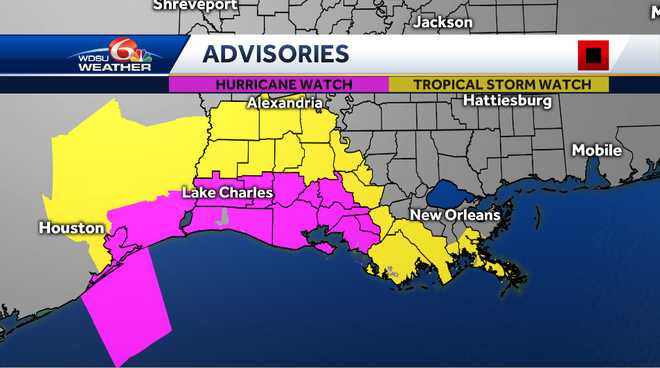
Hurricane and Storm Surge Warnings have been issued for portions of the Upper Texas and Louisiana coastlines.
The latest 7 p.m. update from the National Hurricane Center found that the storm is in the central Gulf — 435 miles southeast of Lake Charles, Louisiana — and moving west-northwest at 17 mph with 85 mph winds.
Over the next couple of days, Laura will move over the warm and deep waters of the Gulf of Mexico while similar or lighter shear conditions continue.

“Now that an inner core appears to be trying to form, conditions appear ripe for at least steady intensification, and rapid intensification is becoming more likely before landfall,” the NHC said in its latest update.
The latest forecast track for Laura indicates that it will reach category 3 hurricane status before making landfall Wednesday night into early Thursday.
That would make Laura the first major hurricane of the 2020 Atlantic hurricane season.
A Tropical Storm Watch has been issued for several parishes in southeast Louisiana, including Terrebonne, Lafourche, lower Plaquemines and lower Jefferson.
A Hurricane Watch is in effect from south of Port Bolivar to San Luis Pass, Texas to Morgan City, Louisiana.
This content is imported from Twitter.
You may be able to find the same content in another format, or you may be able to find more information, at their web site.
A storm surge watch has been issued for a portion of the northwest Gulf Coast. The watch in in effect for several areas, including San Luis Pass, Texas, to Ocean Springs, Mississippi, including Lake Pontchartrain, Lake Maurepas and Lake Borgne, for areas outside of the southeast Louisiana Hurricane and Storm Damage Risk Reduction System.
Laura brought heavy rains and flash flooding over Western Cuba and the Cayman Islands. Hurricane conditions are possible late Wednesday from San Luis Pass, Texas, to west of Morgan City, Louisiana.
Laura is forecast to move over the central and northwest Gulf of Mexico Tuesday night and Wednesday, and approach the northwest coast of the Gulf Wednesday night.
Meanwhile, Tropical Storm Marco made landfall Monday near the mouth of the Mississippi River. With maximum winds of 40 mph, and moving west northwest at 8 mph, the storm made landfall around 6 p.m. Monday, as it will continue to diminish as it parallels the Louisiana coast.
More from WDSU
From watch to warning, know your hurricane terms
It is important to know the difference between the severity of storms during hurricane season.
Below is an explanation so you properly plan for an emergency in the event of a natural disaster.
Tropical storms and hurricanes each have two descriptors, a watch and a warning. A watch means tropical storm or hurricane conditions are possible in the “watch area.” A watch is issued up to 48 hours in advance of the onset of tropical storm-force winds.
A warning is issued when a tropical storm or hurricane conditions are expected in the “warning area.” A warning is issued up to 36 hours in advance of the onset of tropical storm-force winds.
Hurricane preparedness activities become difficult once winds reach tropical storm-force. Watches and warnings are issued in advance of the onset of tropical storm force winds (39-73 mph).
How we rate hurricanes
The Saffir-Simpson Hurricane Wind Scale is a 1 to 5 rating based on a hurricane’s sustained winds, according to the National Oceanic and Atmospheric Administration. Category 3 and above are considered major hurricanes, but precautions should still be taken for Category 1 and 2 storms. NOAA and Weather.gov put together the following information that explains how each storm category is defined and what type of damage is expected.
Tropical Depression
A tropical depression is a tropical cyclone that has maximum sustained surface winds (one-minute average) of 38 mph or less.
Tropical Storm
A tropical storm is a tropical cyclone that has maximum sustained surface winds ranging from 39-73 mph.
Category 1: Sustained winds of 74-95 mph
Very dangerous winds will produce some damage: Well-constructed frame homes could have damage to roofs, shingles, vinyl siding and gutters. Large branches of trees will snap and shallowly rooted trees may be toppled. Extensive damage to power lines and poles likely will result in power outages that could last a few to several days.
Category 2: 96-110 mph
Extremely dangerous winds will cause extensive damage: Well-constructed frame homes could sustain major roof and siding damage. Many shallowly rooted trees will be snapped or uprooted and block numerous roads. Near-total power loss is expected with outages that could last from several days to weeks.
Category 3: 111-129 mph (Major Hurricane)
Devastating damage will occur: Well-built framed homes may incur major damage or removal of roof decking and gable ends. Many trees will be snapped or uprooted, blocking numerous roads. Electricity and water will be unavailable for several days to weeks after the storm passes.
Category 4: 130-156 mph (Major Hurricane)
Catastrophic damage will occur: Well-built framed homes can sustain severe damage with loss of most of the roof structure and/or some exterior walls. Most trees will be snapped or uprooted and power poles downed. Fallen trees and power poles will isolate residential areas. Power outages will last weeks to possibly months. Most of the area will be uninhabitable for weeks or months.
Category 5: 157 mph or higher (Major Hurricane)
Catastrophic damage will occur: A high percentage of framed homes will be destroyed, with total roof failure and wall collapse. Fallen trees and power poles will isolate residential areas. Power outages will last for weeks to possibly months. Most of the area will be uninhabitable for weeks or months.

Proud web evangelist. Travel ninja. Creator. Freelance food nerd. Passionate bacon fanatic.
Proud web evangelist. Travel ninja. Creator. Freelance food nerd. Passionate bacon fanatic.
Proud web evangelist. Travel ninja. Creator. Freelance food nerd. Passionate bacon fanatic.
Proud web evangelist. Travel ninja. Creator. Freelance food nerd. Passionate bacon fanatic.
-
World3 years ago
The Gabby Petito case. Brian Landry set up camp with his family after his girlfriend disappeared
-

 Top News4 years ago
Tristan Thompson reacts to Khloé Kardashian’s new appearance
-
Top News4 years ago
TLC ‘sMothered’ recap: ‘Party curled up,’ boyfriend problem
-
Top News4 years ago
Alex Cooper hosts a solo podcast
-

 Top News4 years ago
2021 Ford Bronco price: Here’s how much the 2-door and 4-door cost
-

 Tech4 years ago
Fall Guys is supplying out a legendary costume and Kudos as an apology present
-
Top News4 years ago
Chiara de Blasio was ‘very cold’ during the arrest of the protest: witness
-
Top News4 years ago
How to Watch Yellowstone Season 3, Episode 2 Live Online