World
Interactive storm radar, latest cone and resources
PHN0eWxlPi5lbWJlZC1yYWRhciB7IGNsZWFyOiBib3RoOyBoZWlnaHQ6IDEwMHZ3OyB9IEBtZWRpYSBvbmx5IHNjcmVlbiBhbmQgKG1pbi13aWR0aDogNDEuMjVyZW0pIHsgLmVtYmVkLXJhZGFyIHsgaGVpZ2h0OiA1MDBweDsgfSB9PC9zdHlsZT4KPHNjcmlwdCB0eXBlPSJ0ZXh0L2phdmFzY3JpcHQiIHNyYz0iaHR0cHM6Ly93aWRnZXRzLWx0cy5tZWRpYS53ZWF0aGVyLmNvbS93eHdpZGdldC5sb2FkZXIuanM/Y2lkPSAyODI4NTI4MDEiPjwvc2NyaXB0Pgo8ZGl2IGNsYXNzPSJlbWJlZC1yYWRhciIgIHJvbGU9Im1haW4iICBhcmlhLWxhYmVsPSJSYWRhciBNYXAgZnJvbSBUaGUgV2VhdGhlciBDb21wYW55LCBhbiBJQk0gQnVzaW5lc3MuIFlvdSBtYXkgYmUgYWJsZSB0byBmaW5kIHRoZSBzYW1lIGNvbnRlbnQgaW4gYW5vdGhlciBmb3JtYXQsIG9yIHlvdSBtYXkgYmUgYWJsZSB0byBmaW5kIG1vcmUgaW5mb3JtYXRpb24sIGF0IFdlYXRoZXIuY29tIj4KPHd4LXdpZGdldCB0eXBlPSJtYXAiIGxhdGl0dWRlPSIzMC4yMTA1NjA2IiBsb25naXR1ZGU9Ii03OS4zMjkwNzgiIG1lbnVpdGVtcz0iMDAxNSwwMDAxLDAwMTcsMDAyMSIgbWFwaWQ9IjAwMjIiIG1lbWJlcmlkPSIxMTY5IiB6b29tbGV2ZWw9IjQiIHN0YW5kYWxvbmU9InRydWUiIG9wYWNpdHk9Ii42IiBmdWxsc2NyZWVuPSJ0cnVlIiBoZWFkZXI9ImZhbHNlIiBqcz0ibHRzIiBhbmltYXRlPSJ0cnVlIj48L3d4LXdpZGdldD4KPC9kaXY+Tropical Storm Laura is now moving over Northern Louisiana as of 1 p.m. according to the National Hurricane Center. The hurricane made landfall in southwestern Louisiana as a Category 4 storm. The extremely powerful storm made landfall in Cameron, Louisiana, with 150 mph winds just before 1 a.m. Thursday.It’s the strongest hurricane to make a Louisiana landfall since 1856.The storm continues to push northward but is weakening, with winds at 65 mph as of 1 p.m.It is 65 miles east northeast from Shreveport.The storm grew nearly 87% in power in just 24 hours to a size the National Hurricane Center called “extremely dangerous.” Drawing energy from the warm Gulf of Mexico, the system arrived during high tide as the most powerful hurricane to strike the U.S. so far this year.Louisiana Gov. John Bel Edwards has activated the state’s entire National Guard, expecting widespread devastation across the hurricane’s path.On the forecast track, Laura will move inland across southwestern Louisiana Thursday morning. This motion should continue through the day.Laura will then continue northward across the state through this afternoon. The center of Laura is forecast to move over Arkansas Thursday night, then over the mid-Mississippi Valley on Friday, and the mid-Atlantic states on Saturday.A Tropical Storm Watch has been cancelled for several parishes in southeast Louisiana, including Terrebonne, Lafourche, lower Plaquemines and lower Jefferson.A Storm Surge Warning is in effect from San Luis Pass, Texas to Port Fourchon. APP USERS: Tap here for the full experienceLATEST CONELATEST MODELSATLANTIC SATELLITEGULF SATELLITE12-HOUR FORECAST7-DAY FORECASTSATELLITE VIEW 1SATELLITE VIEW 2More from WDSUCLICK HERE for the latest forecast and videocastGet Ready Now: What to include in a hurricane kitWhat to know about evacuation plans, contraflow in LouisianaHow to prepare your pets for hurricane seasonHere is a list of parish and county emergency contact information Resources for those with disabilities, functional needs ahead of tropical weatherFrom watch to warning, know your hurricane termsIt is important to know the difference between the severity of storms during Hurricane Season.Below is an explanation so you properly plan for an emergency in the event of a natural disaster.Tropical storms and hurricanes each have two descriptors, a watch and a warning. A Watch means tropical storm or hurricane conditions are possible in the “watch area.” A watch is issued up to 48 hours in advance of the onset of tropical storm-force winds.A Warning is issued when a tropical storm or hurricane conditions are expected in the “warning area.” A Warning is issued up to 36 hours in advance of the onset of tropical storm-force winds.Hurricane preparedness activities become difficult once winds reach tropical storm-force. Watches and Warnings are issued in advance of the onset of tropical storm force winds (39-73 mph)How we rate hurricanesThe Saffir-Simpson Hurricane Wind Scale is a 1 to 5 rating based on a hurricane’s sustained winds, according to the National Oceanic and Atmospheric Administration. Category 3 and above are considered major hurricanes, but precautions should still be taken for Category 1 and 2 storms. NOAA and Weather.gov put together the following information that explains how each storm category is defined and what type of damage is expected.Tropical DepressionA tropical depression is a tropical cyclone that has maximum sustained surface winds (one-minute average) of 38 mph or less.Tropical StormA tropical storm is a tropical cyclone that has maximum sustained surface winds ranging from 39-73 mph.Category 1: Sustained winds of 74-95 mphVery dangerous winds will produce some damage: Well-constructed frame homes could have damage to roof, shingles, vinyl siding and gutters. Large branches of trees will snap and shallowly rooted trees may be toppled. Extensive damage to power lines and poles likely will result in power outages that could last a few to several days.Category 2: 96-110 mphExtremely dangerous winds will cause extensive damage: Well-constructed frame homes could sustain major roof and siding damage. Many shallowly rooted trees will be snapped or uprooted and block numerous roads. Near-total power loss is expected with outages that could last from several days to weeks.Category 3: 111-129 mph (Major Hurricane)Devastating damage will occur: Well-built framed homes may incur major damage or removal of roof decking and gable ends. Many trees will be snapped or uprooted, blocking numerous roads. Electricity and water will be unavailable for several days to weeks after the storm passes.Category 4: 130-156 mph (Major Hurricane)Catastrophic damage will occur: Well-built framed homes can sustain severe damage with loss of most of the roof structure and/or some exterior walls. Most trees will be snapped or uprooted and power poles downed. Fallen trees and power poles will isolate residential areas. Power outages will last weeks to possibly months. Most of the area will be uninhabitable for weeks or months.Category 5: 157 mph or higher (Major Hurricane)Catastrophic damage will occur: A high percentage of framed homes will be destroyed, with total roof failure and wall collapse. Fallen trees and power poles will isolate residential areas. Power outages will last for weeks to possibly months. Most of the area will be uninhabitable for weeks or months.
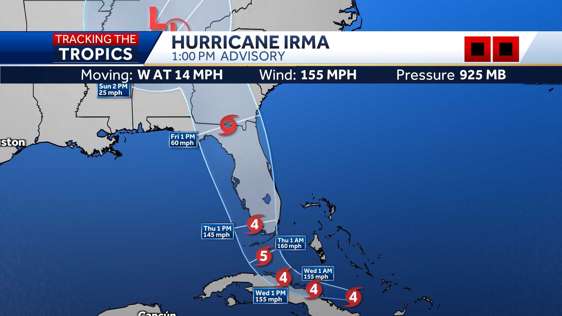
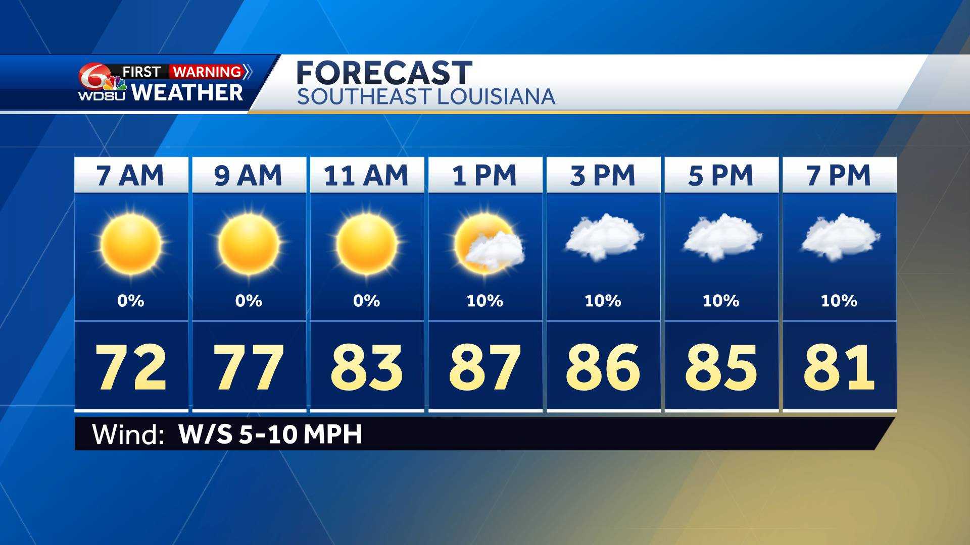
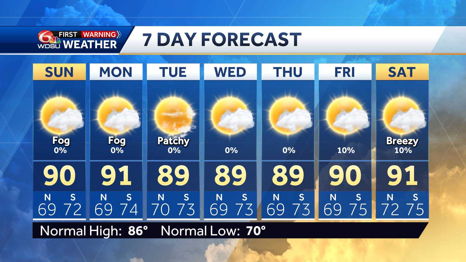
Tropical Storm Laura is now moving over Northern Louisiana as of 1 p.m. according to the National Hurricane Center.
The hurricane made landfall in southwestern Louisiana as a Category 4 storm. The extremely powerful storm made landfall in Cameron, Louisiana, with 150 mph winds just before 1 a.m. Thursday.
It’s the strongest hurricane to make a Louisiana landfall since 1856.
The storm continues to push northward but is weakening, with winds at 65 mph as of 1 p.m.
It is 65 miles east northeast from Shreveport.
The storm grew nearly 87% in power in just 24 hours to a size the National Hurricane Center called “extremely dangerous.” Drawing energy from the warm Gulf of Mexico, the system arrived during high tide as the most powerful hurricane to strike the U.S. so far this year.
Louisiana Gov. John Bel Edwards has activated the state’s entire National Guard, expecting widespread devastation across the hurricane’s path.
On the forecast track, Laura will move inland across southwestern Louisiana Thursday morning. This motion should continue through the day.
Laura will then continue northward across the state through this afternoon. The center of Laura is forecast to move over Arkansas Thursday night, then over the mid-Mississippi Valley on Friday, and the mid-Atlantic states on Saturday.
A Tropical Storm Watch has been cancelled for several parishes in southeast Louisiana, including Terrebonne, Lafourche, lower Plaquemines and lower Jefferson.
A Storm Surge Warning is in effect from San Luis Pass, Texas to Port Fourchon.
APP USERS: Tap here for the full experience
LATEST CONE
LATEST MODELS
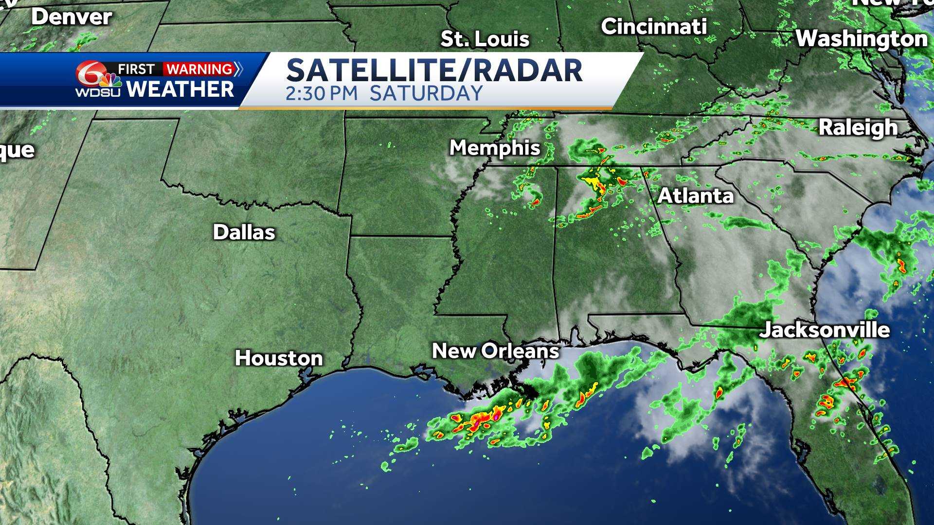
ATLANTIC SATELLITE
GULF SATELLITE
12-HOUR FORECAST
7-DAY FORECAST
SATELLITE VIEW 1
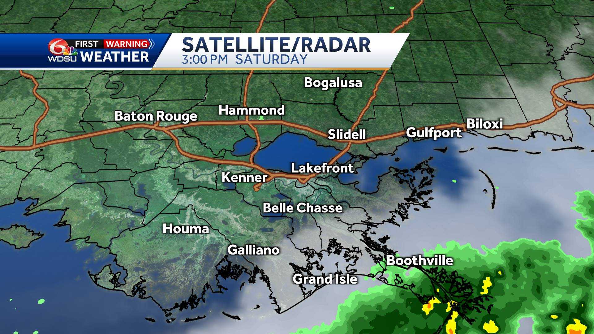
SATELLITE VIEW 2
More from WDSU
From watch to warning, know your hurricane terms
It is important to know the difference between the severity of storms during Hurricane Season.
Below is an explanation so you properly plan for an emergency in the event of a natural disaster.
Tropical storms and hurricanes each have two descriptors, a watch and a warning. A Watch means tropical storm or hurricane conditions are possible in the “watch area.” A watch is issued up to 48 hours in advance of the onset of tropical storm-force winds.
A Warning is issued when a tropical storm or hurricane conditions are expected in the “warning area.” A Warning is issued up to 36 hours in advance of the onset of tropical storm-force winds.
Hurricane preparedness activities become difficult once winds reach tropical storm-force. Watches and Warnings are issued in advance of the onset of tropical storm force winds (39-73 mph)
How we rate hurricanes
The Saffir-Simpson Hurricane Wind Scale is a 1 to 5 rating based on a hurricane’s sustained winds, according to the National Oceanic and Atmospheric Administration. Category 3 and above are considered major hurricanes, but precautions should still be taken for Category 1 and 2 storms. NOAA and Weather.gov put together the following information that explains how each storm category is defined and what type of damage is expected.
Tropical Depression
A tropical depression is a tropical cyclone that has maximum sustained surface winds (one-minute average) of 38 mph or less.
Tropical Storm
A tropical storm is a tropical cyclone that has maximum sustained surface winds ranging from 39-73 mph.
Category 1: Sustained winds of 74-95 mph
Very dangerous winds will produce some damage: Well-constructed frame homes could have damage to roof, shingles, vinyl siding and gutters. Large branches of trees will snap and shallowly rooted trees may be toppled. Extensive damage to power lines and poles likely will result in power outages that could last a few to several days.
Category 2: 96-110 mph
Extremely dangerous winds will cause extensive damage: Well-constructed frame homes could sustain major roof and siding damage. Many shallowly rooted trees will be snapped or uprooted and block numerous roads. Near-total power loss is expected with outages that could last from several days to weeks.
Category 3: 111-129 mph (Major Hurricane)
Devastating damage will occur: Well-built framed homes may incur major damage or removal of roof decking and gable ends. Many trees will be snapped or uprooted, blocking numerous roads. Electricity and water will be unavailable for several days to weeks after the storm passes.
Category 4: 130-156 mph (Major Hurricane)
Catastrophic damage will occur: Well-built framed homes can sustain severe damage with loss of most of the roof structure and/or some exterior walls. Most trees will be snapped or uprooted and power poles downed. Fallen trees and power poles will isolate residential areas. Power outages will last weeks to possibly months. Most of the area will be uninhabitable for weeks or months.
Category 5: 157 mph or higher (Major Hurricane)
Catastrophic damage will occur: A high percentage of framed homes will be destroyed, with total roof failure and wall collapse. Fallen trees and power poles will isolate residential areas. Power outages will last for weeks to possibly months. Most of the area will be uninhabitable for weeks or months.

Proud web evangelist. Travel ninja. Creator. Freelance food nerd. Passionate bacon fanatic.
Proud web evangelist. Travel ninja. Creator. Freelance food nerd. Passionate bacon fanatic.
Proud web evangelist. Travel ninja. Creator. Freelance food nerd. Passionate bacon fanatic.
Proud web evangelist. Travel ninja. Creator. Freelance food nerd. Passionate bacon fanatic.
-
World3 years ago
The Gabby Petito case. Brian Landry set up camp with his family after his girlfriend disappeared
-

 Top News4 years ago
Tristan Thompson reacts to Khloé Kardashian’s new appearance
-
Top News4 years ago
TLC ‘sMothered’ recap: ‘Party curled up,’ boyfriend problem
-
Top News4 years ago
Alex Cooper hosts a solo podcast
-

 Top News4 years ago
2021 Ford Bronco price: Here’s how much the 2-door and 4-door cost
-

 Tech4 years ago
Fall Guys is supplying out a legendary costume and Kudos as an apology present
-
Top News4 years ago
Chiara de Blasio was ‘very cold’ during the arrest of the protest: witness
-
Top News4 years ago
How to Watch Yellowstone Season 3, Episode 2 Live Online